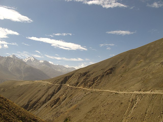
The Pamir Highway, also referred to as the M41, embodies a legendary journey winding through some of Central Asia’s most remote and awe-inspiring landscapes. Regarded as one of the planet’s most mythical and perilous roads, it stands shoulder to shoulder with infamous routes like the Death Road, the Karakoram, and the Kolyma Highway.
Officially designated as the M41 highway, this thoroughfare traverses the vast expanse of Central Asia, threading its way across the Pamir Mountains and spanning four countries: Afghanistan, Uzbekistan, Tajikistan, and Kyrgyzstan.
| Countries | Afghanistan, Uzbekistan, Tajikistan, Kyrgyzstan |
| Length | 1,600 kilometers (1,000 miles) |
| Cordillera | Pamir, Asia Central |
| Cities | Mazari Sharif,(Afghanistan) y Osh (Kyrgyzstan) |
| Elevation | 4,655 meters (15,270 ft) |
Spanning over 1,600 kilometers (1,000 miles), this iconic highway navigates the rugged Pamir Mountains, offering adventurous souls a glimpse into a realm where time appears to pause. Linking the cities of Dushanbe in Tajikistan and Osh in Kyrgyzstan, the Pamir Highway meanders through some of Earth’s most pristine and untamed landscapes. A standout feature of this historic route is its awe-inspiring elevation, with certain segments soaring beyond 4,000 meters above sea level. Towering above them all is the Ak-Baital Pass, reaching a breathtaking 4,655 meters (15,270 ft) and presenting panoramic vistas of the surrounding peaks. The road is renowned as the world’s second-highest international highway.

Cities and Countries on the Route
The inception point of the Pamir Highway is a subject of debate, contingent upon whom you inquire. In Afghanistan, it’s asserted to commence from Mazari Sharif, while in Uzbekistan, the contention shifts to Termez, and in Tajikistan, Dushanbe is designated as the starting point. Our preference leans towards the longer route, thus we embark from Mazari Sharif, Afghanistan, journeying through a tapestry of cultural richness until reaching Osh, Kyrgyzstan, the terminus.
The Pamir Highway meanders through a constellation of cities and towns, each offering a window into the vibrant cultural mosaic of the region. Commencing from Dushanbe, the capital of Tajikistan, travelers traverse through Murghab, Khorog, and Ishkashim before crossing into Kyrgyzstan, culminating the journey amidst the bustle of Osh.
This historic roadway once served as a pivotal link in the ancient Silk Road trade route, with divergent opinions regarding its starting and ending points. Mazari Sharif, Afghanistan, Termiz, Uzbekistan, Dushanbe, Tajikistan, and Khorog, Tajikistan all lay claim to its origins, embodying the richness of its historical significance.
Scattered along the Pamir Highway are a plethora of attractions, showcasing the natural splendor and cultural heritage of the region. From the serene azure expanse of Karakul Lake to the ancient bastions of Kah-Kaha, each stop along the way presents travelers with a tantalizing glimpse into the captivating tapestry of Central Asian history and culture. The Pamir Highway’s section between Dushanbe and Murghab forms part of the European Route E 008.

Dushanbe, the city that combines antiquity and modernity, euronews.com

Camels close to the Pamir Highway
History
The narrative of the Pamir Highway mirrors the diverse landscapes it winds through. Originating as a strategic military thoroughfare crafted by the Soviet Union in the 1930s, this highway assumed pivotal importance as a supply conduit during World War II. Across time, it metamorphosed into a vital artery for the remote enclaves scattered amidst the Pamir Mountains, fostering commerce and connectivity between Tajikistan, Kyrgyzstan, and neighboring realms.
Constructed in phases spanning the 19th century and the 1930s, the Pamir Highway, designated as route M-41 in Tajikistan and Kyrgyzstan, claims the distinction of being the world’s second-highest international highway. Varied construction standards and maintenance regimes prevail along its course, evident especially in the section between Dushanbe and Murghab, labeled with the European route number E008.
This ancient conduit has endured for millennia, serving as a linchpin in the illustrious Silk Road network. Meandering through the harsh, arid terrain of the Pamir Mountains, the highway has acquired the epithet “the road from hell.” Maintenance endeavors, initiated during the Soviet era, have been sporadic, with emphasis typically directed towards areas ravaged by natural calamities such as flash floods and landslides.

Pamir Highway, Wakhan-Valley between Murghab and Vrang
Driving the Pamir Highway
Traveling the Pamir Highway presents a formidable adventure, winding through some of the most remote and challenging terrain on Earth. With harsh weather conditions, rugged roads, and high altitudes, even seasoned travelers face significant obstacles. The region’s susceptibility to seismic activity, including earthquakes and landslides, adds to the hazards along the route. Navigating the Pamir Highway demands experienced, cautious driving to mitigate risks.
Traveling along the Pamir Highway feels like entering a parallel world, where the landscape is both breathtaking and treacherous. With narrow, single-lane roads winding along steep valleys and sheer cliffs, any driving error can have dire consequences. The absence of barriers heightens the sense of danger, while the expansive blue sky adds an air of mystery to the journey.
Despite the challenges, the Pamir Highway beckons adventurers with its unparalleled grandeur. Popular among 4×4 off-road enthusiasts, motorcyclists, and even daring cyclists, the route offers an exhilarating challenge. While much of the road is paved, sections are marred by erosion, landslides, and avalanches, requiring careful navigation. Weather conditions, with altitudes often exceeding 4,000 meters, bring dry and bitterly cold temperatures, further adding to the adventure.
Dubbed the “Heroin Highway” due to its use in drug trafficking, the Pamir Highway remains open year-round, though closures due to snow are possible at any time. Despite its risks, traversing this legendary route promises an unforgettable journey through some of the world’s most awe-inspiring landscapes.


