(3 votes, average: 4.33 out of 5)
The Trans-Saharan Highway (officially TAH 2, also known as the African Unity Road) is a transborder road approximately 4,500 kilometers long, connecting Algeria to Nigeria, crossing Niger from north to south. Approximately 85% of the road is paved. The road is nearing completion to pave, when the remaining 15% is completed, the Trans-Saharan Highway will enhance and streamline border procedures on its trade route through the Sahara Desert.
- Length: Length 4,504 km (2,799 mi)
- North & South Ends: Algiers, Algeria and Lagos,Nigeria
- Type of road: 98% paved
- Countries: Algeria, Niger, Nigeria
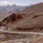
The Trans-Sahara Highway, proposed in 1962 and with sections in the Sahara under construction since the 1970s, stands as one of Africa’s oldest and most comprehensive transnational highways. However, its central section sees limited use, presently off-limits to tourists, necessitating military convoys. This restriction arises from security concerns in Algeria and the risks associated with migrant trafficking, leading to insecurity in northern Niger.
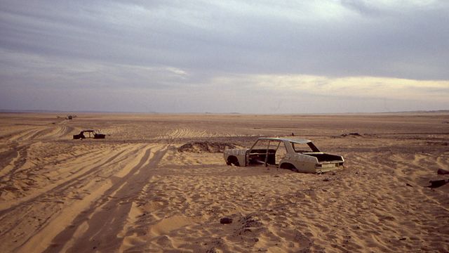
Abandoned car near the border between Algeria and Niger
Driving the Trans-Saharan Highway
The construction of a network of highways in Africa to promote economic development on the continent is much needed, although at times it may seem like a fantastical idea. Being able to cross the Mediterranean by ferry from Europe and drive from Algiers to Lagos sounds like a highly appealing adventure. Perhaps one day, when the Trans-Saharan Highway is completed, this will become a feasible journey.
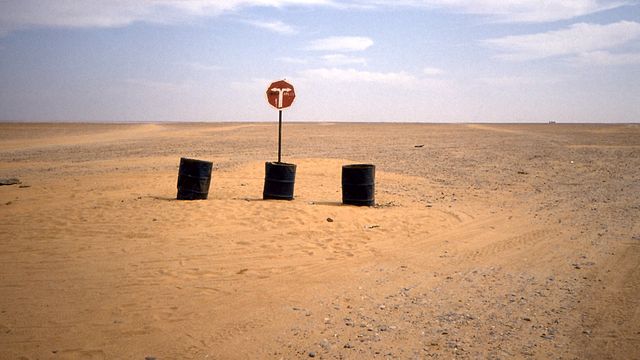
Road sign on the Trans-Saharan Highway in Niger. Turn right to go to Arlit
For now, traveling these 4,500 kilometers remains a daunting task. While it is riddled with security risks in some sections, the greatest danger is facing one of the harshest environments in the world. Temperatures in the heart of the Sahara are scorching, and fuel and water are scarce along much of the route, so it’s best not to expect the fuel tank to reach reserve or the car radiator to keep functioning. In addition to all this, newly paved parts of the road often disappear under immense sand dunes that block the route for days, making navigation extremely challenging.
Adding to the difficulties, it’s crucial to keep in mind that for most of the journey, you are in the middle of nowhere, making expertise in mechanics not just recommended but mandatory. Patience with bureaucratic processes is also required, as the procedures at the two border crossings can be endlessly time-consuming.
Nevertheless, this road calls out to the most adventurous, those seeking a journey with challenges on an almost impossible route but providing the opportunity to taste the Sahara in the most authentic way
The Trans-Saharian road route
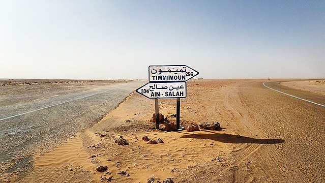
Crossing on the Trans-Saharan Highway between Timmimoun and Ain Salah
Trans-Sahara road in Algeria
More than half of the road, about 2,300 km, is located in Algeria, but particularly south of In Salah, a significant portion of it is in poor condition, susceptible to floods from the Hoggar Mountains, and requires constant maintenance. In 2007, the southern half of the 400 km stretch from Tamanrasset to In Guezzam, on the border with Niger, was sealed.
| Distance | Road condition | |
|---|---|---|
| Algiers to Ghardaia | 388 miles (625 km) | Paved, in good condition |
| Ghardaia to Tamanrasset | 801 miles (1,291 km) | Paved, in good condition |
| Tamanrasset a Guezzam (Algeria - Niger border control) | 248 miles (400 km) | Partially paved, accessible by non-4WD vehicles |
Trans-Sahara road in Níger
Niger is responsible for about 985 km of the road, of which 655 km are paved but also in poor condition.
| Distance | Road condition | |
|---|---|---|
| Guezzam to Assamaka | 17 miles (28 km) | Unpaved. Fine sand, accessible by non-4x4 vehicles, but not recommended |
| Assamaka to Arlit | 124 miles (200 km) | Fine sand, accessible by non-4x4 vehicles |
| Arlit to Agadez | 151 miles (243 km) | Paved, in poor condition |
| Agadez to Zinder | 267 miles (430 km) | 200 miles paved, 167 unpaved |
| Zinder to Nigeria (border post) | 69 miles (111 km) | Paved, in poor condition |
Trans-Sahara road in Nigeria
The 1,200 km of the road in Nigeria is part of the country’s national network of paved roads, including about 500 kilometers of four-lane road, although road maintenance is often lacking.
| Distance | Road condition | |
|---|---|---|
| Niger to Lagos Border | 741 miles (1,193 km) | Paved, good condition |
Tran-Saharan Highway in Google Maps
Other options for bypassing the Sahara by road
Two other trans-African highways cross the Sahara, skirting its edges. In the Northwest, the Cairo-Dakar highway (TAH 1) winds its way for 8,636 kilometers along the Atlantic and Mediterranean coasts. Heading South, the Cairo-Cape Town road (TAH 5), spanning 10,228 km, follows the Nile to the east but has unpaved sections in Sudan, Ethiopia, and Kenya.