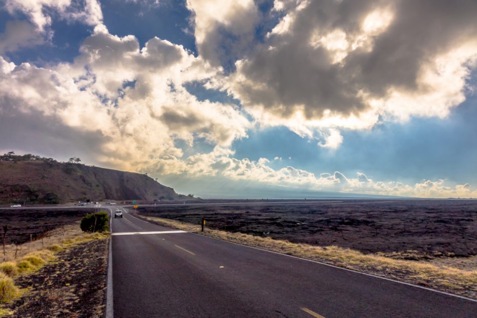
The Saddle Road, also known as Hawaii State Highway 200 or Ala Mauna Saddle Road, is a road that crosses the island of Hawaii, serving as an important route connecting the cities of Hilo on the east coast and Kailua-Kona on the west coast. Like the Hana Highway, it is a scenic road that offers breathtaking views.
The road, spanning approximately 85 kilometers, cuts through the heart of the island of Hawaii and passes through Hawaii Volcanoes National Park. Along its path, it encounters two volcanoes that provide stunning panoramic views: Mauna Kea, standing at 4,205 meters, and Mauna Loa, standing at 4,169 meters. Mauna Loa is actually larger in terms of volume and surface area and is considered the largest volcano on Earth. During the journey, Saddle Road reaches a maximum elevation of 2,021 meters, even though the town of Hilo is at sea level.

Saddle Road, Bill Watson
Driving Saddle Road
Due to its location on the island and its altitude, the road can be quite steep and have variable weather conditions, so it is recommended to exercise caution when driving on it. For many years, Saddle Road was considered a dangerous and poorly maintained road, but in recent years, it has undergone significant improvements to make it safer and more accessible.
Improvements have been made to the pavement, signage, and overall driving conditions. However, it is important to note that conditions can change rapidly due to weather and volcanic activity, so it is advisable to check the road conditions before embarking on a journey on it.

Mist at Saddle Road, Mana Ke’a
Saddle Road: Tourist Attractions
During the journey along Saddle Road on the island of Hawaii, there are several points of interest and places to visit. Some of them include:
- Hawai’i Volcanoes National Park: Located in the southern part of the road, it is one of the main attractions on the island. Here, you can explore active volcanoes, hike along scenic trails, and visit the famous Halema’uma’u crater.
- Mauna Kea: Saddle Road passes near Mauna Kea volcano, the highest peak in Hawaii. It is a popular destination for stargazing and also hosts several astronomical observatories.
- Pu’u Huluhulu State Park: Located near the midpoint of the road, this state park offers beautiful panoramic views of the island and a variety of hiking trails.
- Kalōpā State Park: Situated in the Kohala Mountains, this state park features picturesque trails, lush botanical gardens, and picnic areas.
- Waterfalls: Along Saddle Road, there are several stunning waterfalls that can be visited, such as Rainbow Falls and Akaka Falls.
- Hilo: Near the eastern end of the road, you will find the city of Hilo, which offers a wide range of shops, restaurants, botanical gardens, and museums.

Saddle Road, Kan Walk Will Travel

Saddle Road, foto de Kan Walk Will Travel
Saddle Road in Google Maps
The history of Saddle Road

Curves and mist, Saddle Road, Elyse Butler Mallams
The idea for the road came from the Minister of Finance at the time, Gerrit P. Judd, who in 1849 proposed connecting the two most populous areas of the island of Hawaii. Penitentiary labor was used, and after the first 10 years of work, only 19 kilometers were built. However, the work had to cease when the eruption of the Mauna Loa volcano caused a sea of lava to cover part of the route.
After World War II in 1945, the United States Army took jurisdiction over the road, and it was then named and designed as the current Hawaii State Highway 200. Despite this, the local government did not have enough funds to maintain the road adequately, so civilians were responsible for its upkeep and improvement. Most of the original pavement from that time remained until the present century.
Afterwards, Saddle Road remained neglected until 2004. It was a road with little maintenance, narrow, and dangerous, to the extent that many car rental companies in Hawaii prohibited driving their cars on this road.
Despite the improvements, there are still very narrow stretches, and during the rainy season or when the fog descends, visibility can be zero, requiring extremely cautious driving. All these reasons make this road a mandatory passage for anyone with the idea of traveling to Hawaii.
Spanish version of this road: Saddle Road


 (4 votes, average: 4.50 out of 5)


