(2 votes, average: 4.00 out of 5)
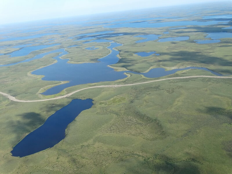
The Inuvik-Tuktoyaktuk Highway is a remarkable winter road in Canada connecting the communities of Inuvik and Tuktoyaktuk in the Northwest Territories. Also known as the Dempster Highway Extension, it is the first all-weather road to the Arctic Ocean and spans approximately 137 kilometers (85 miles). The construction process began in 2014 and was constructed in stages, with the official opening taking place on November 15, 2017. The highway is designed to be open all year long, providing a reliable and continuous transportation link between Inuvik and Tuktoyaktuk. The ITH includes eight bridges, and is a two-lane gravel road for its entirety.
| Name | Inuvik-Tuktoyaktuk Highway |
| Length | 137 kilometers (85 miles) |
| Location | Northwest Territories, Canada |
| North & South end | Tuktoyaktuk & Inuvik (Dempster Highway) |
| Is the highway to Inuvik paved? | No, it's a gravel |
| Is the road to Tuktoyaktuk closed? | No, its open all year long |
10 key points and interesting facts about this unique highway
- Arctic Connection: The highway is a critical transportation link that provides year-round access to the Arctic coastline. Before its construction, Tuktoyaktuk was only accessible by ice road in the winter or by air, making the community somewhat isolated during other seasons.
- Construction: The construction of the highway began in 2014, and it officially opened in November 2017.
- Permafrost Challenges: One of the engineering challenges faced during construction was the presence of permafrost in the region. Special construction techniques, such as using insulated gravel pads, were employed to prevent the thawing of permafrost, ensuring the road’s stability.
- Historical Significance: Tuktoyaktuk, often referred to as “Tuk,” is known for its cultural and historical significance. It was a traditional Inuvialuit hunting and fishing location and has been a meeting place for centuries.
- Ice Road Alternative: Prior to the highway’s construction, Tuktoyaktuk was connected to Inuvik and the rest of the region via an ice road during the winter months. The new highway now provides a reliable year-round alternative, enhancing transportation and economic opportunities.
- Economic Impact: The highway has had a positive impact on the local economy by facilitating the movement of goods, services, and people. It has also opened up opportunities for tourism and resource development in the region.
- Arctic Scenery: Traveling along the Inuvik-Tuktoyaktuk Highway offers breathtaking views of the Arctic landscape, with vast tundra, frozen lakes, and unique wildlife. It provides a rare chance for travelers to experience the beauty of the Arctic firsthand.
- Ice Road Film Location: The construction and opening of the highway attracted attention from filmmakers. The area has been used as a location for filming scenes in movies and documentaries that showcase the challenges of building infrastructure in the Arctic.
- Cultural Exchange: The highway serves as a physical link that promotes cultural exchange between Inuvik and Tuktoyaktuk, fostering a stronger sense of community and connectivity between the two locations.
- Tourist Attraction: The Inuvik-Tuktoyaktuk Highway has become a tourist attraction in its own right, drawing visitors who want to experience the remote and unique beauty of the Arctic landscape and the communities it connects.
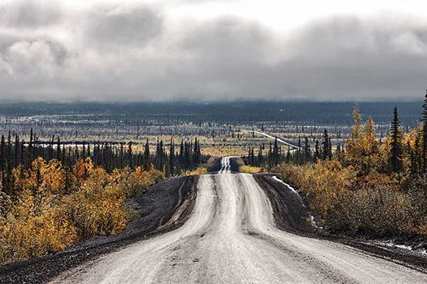
Fall on the Inuvik Tuktoyaktuk Highway, photo by www.cbc.ca
In conclusion, the Inuvik-Tuktoyaktuk High
way is not just a transportation route; it represents a triumph of engineering over challenging Arctic conditions, connecting communities, fostering economic development, and providing a gateway for people to experience the wonders of the far North.
What to see in the Inuvik-Tuktoyaktuk Highway
The Inuvik-Tuktoyaktuk Highway starts in Inuvik, a town in the Northwest Territories, Canada. It then extends northward for approximately 137 kilometers (85 miles) to reach Tuktoyaktuk on the Arctic Ocean coast. Along the way, there are several points of interest and scenic spots to explore:
Inuvik
Start your journey in Inuvik, known for its unique Midnight Sun and vibrant cultural community. Visit the Igloo Church, a distinctive landmark with an unusual design.
What to see in Inuvik
- Holy Trinity Anglican Church: This Anglican church is famous for its unique igloo-shaped design and beautiful interior.
- Inuvik Community Greenhouse: It is the first and northernmost commercial agriculture facility in the Arctic. Here, you can explore gardens, learn about innovative cultivation methods, and enjoy fresh local produce.
- Northern Lights (Aurora Borealis): Inuvik is a prime location to witness the natural wonder of the Northern Lights. During the winter months, there are many opportunities to enjoy this luminous display in the Arctic sky.
- Cultural Festivals: The Inuvik community celebrates various festivals throughout the year, such as the Muskrat Jamboree, featuring traditional activities, Inuit music, and dances.
Arctic Circle & Mackenzie River
The highway crosses the Arctic Circle, providing a memorable milestone for travelers. Encounter the Mackenzie River, one of the longest rivers in North America. Take in the views from the highway.
Tsiigehtchic
A small community at the confluence of the Arctic Red and Mackenzie Rivers. Experience local culture and hospitality. Tsiigehtchic offers stunning views and a connection to the natural environment. The community is known for its cultural traditions, and visitors may have the opportunity to learn about the Gwich’in way of life and their historical connection to the land.
Tuktoyaktuk
The settlement of Tuktoyaktuk, formerly known as Port Brabant and home to just under 1,000 people, changed its name in the 1950s, becoming the first place in Canada to be renamed with its native name. Tuktoyaktuk, commonly called Tuk, literally means “it looks like a caribou” in Inuvialuktun, the native language of the Inuit people inhabiting northern Canada. The place receives very few visitors and lacks both restaurants and hotels, so if you plan to travel to Canada and venture into this inhospitable location, don’t forget to bring provisions.
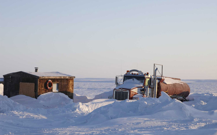
Tuktoyaktuk, a truck buried under the snow, photo by www.trucktrend.com
What to see in Tuktoyaktuk
- Canadian Landmark: Tuktoyaktuk is famous for hosting pingos, ice-covered hills with unique vegetation in this region. The Canadian Landmark Pingo is a protected area that harbors several stunning pingos, where visitors can admire their natural beauty and learn about their formation.
- Inuvialuit Culture: Tuktoyaktuk is home to the Inuvialuit community, and visitors have the opportunity to immerse themselves in its rich culture and traditions. You can visit the local cultural center to learn about the community’s history, traditional hunting and fishing practices, and enjoy cultural events such as dances and Inuit music.
- Bird Watching: Tuktoyaktuk’s coastal location attracts a diverse array of migratory birds during the summer months. Birdwatching enthusiasts can enjoy the opportunity to spot seabirds, gulls, eagles, and other species that gather in the area.
Driving the Inuvik-Tuktoyaktuk Highway
While the Inuvik-Tuktoyaktuk Highway offers a unique and unforgettable journey, it’s essential to be well-prepared for the challenging conditions of the Arctic environment. With proper planning and precautions, a road trip along this highway can be a once-in-a-lifetime adventure.
- Vehicle Preparation: Ensure your vehicle is well-maintained and equipped for winter driving conditions. Check the tires, brakes, battery, and fluids. Carry a spare tire, tools, and emergency supplies.
- Winter Driving: Be prepared for winter weather, including snow and ice. Drive cautiously and adjust your speed to road conditions. Pack warm clothing, blankets, and extra provisions in case of unexpected delays.
- Fuel Considerations: Gas stations are limited, so ensure you have a full tank before starting the journey. Consider carrying extra fuel containers, especially if traveling in winter when fuel consumption may increase.
- Communication: Mobile phone coverage may be limited. Consider a satellite phone or other communication devices for emergencies.
- Road Conditions: Check road conditions and weather forecasts before starting the trip. Be aware of potential closures or advisories, especially in severe winter weather.
- Wildlife Awareness: Watch out for wildlife, particularly on the road, and be cautious, especially during dawn and dusk.
- Emergency Kit: Pack a comprehensive emergency kit, including a first aid kit, flashlight, batteries, non-perishable food, and water.
- Community Respects: Respect local communities and their cultures. Follow any local guidelines or rules when visiting towns along the route.
- Travel Insurance: Consider travel insurance that covers potential challenges associated with remote Arctic travel.
- Northern Lights: If visiting during the winter, you might have the opportunity to witness the mesmerizing Northern Lights. Check the forecast and plan accordingly.
Arctic Ocean sign Tuktoyaktuk
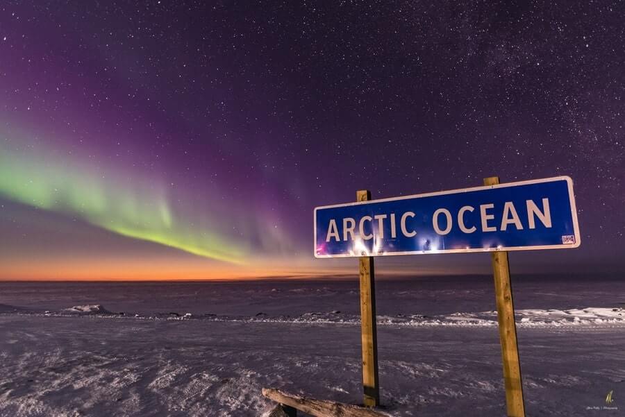
Foto by Chris Kelly
The Arctic Ocean Sign in Tuktoyaktuk is a notable landmark that marks the northernmost point of the Inuvik-Tuktoyaktuk Highway and the road’s culmination at the Arctic Ocean. This sign, often referred to as the “Arctic Ocean Sign” or “Tuktoyaktuk Sign,” is located near the coastline and signifies the accomplishment of reaching the Arctic Ocean via a road network. It has become an iconic spot for visitors and travelers who complete the journey along the highway. The sign typically features the name “Tuktoyaktuk” and may include information about the Arctic Ocean and the significance of the location in the far north of Canada. It serves as a popular photo opportunity for those exploring the region and experiencing the unique charm of Tuktoyaktuk.
The old ice Tuktoyaktuk Highway
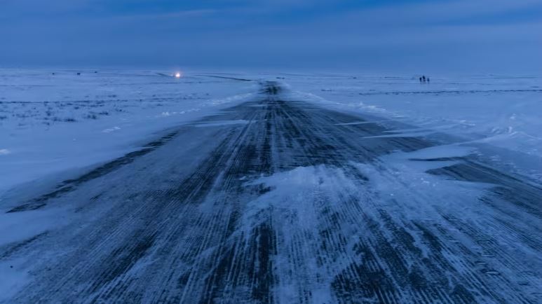
The old Tuktoyaktuk ice road by night, photo by www.cbc.ca
Before its construction, Tuktoyaktuk was connected to Inuvik and the rest of the region by an ice road during the winter months and by air during other seasons. On April 29, 2017, the Inuvik to Tuktoyaktuk ice road closed forever. All vehicle traffic between the two communities is now via the new all-weather road. The Inuvik-Tuktoyaktuk Highway eliminated the seasonal limitations, allowing for year-round travel and transportation between these Arctic communities. It was possible to drive on the old Inuvik-Tuktoyaktuk old Highway from mid-December to late April, depending on ice conditions. Despite the two and a half meters of ice road available, driving on it was extremely dangerous, as it is full of cracks, and the traffic consists of giant trailers loaded with gas. Nevertheless, there weren’t many accidents since the traffic is very light. During the summer, when the ice turned into water, its transit was impossible, so the only means to reach Tuktoyaktuk was by air or sea. This old road gained relative popularity after its appearance in the second season of the TV show Ice Road Truckers on the History channel.

Photo by www.trucktrend.com
Tuktoyaktuk road in Google Maps
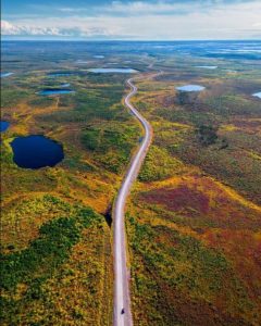
Header photo: Aerial view during the summer of the Tuktoyaktuk Winter Road, near the village of the same name. Photo by Adam Jones